Projects

Cancel
  • connRAD

    Connectivity & resilience for automated driving functions in Germany

    Eclipse Mosaic zum Schutz von Verkehrsteilnehmenden.
    © Philipp Plum / Fraunhofer FOKUS

    The ConnRAD project aims to develop system architectures as well as communication protocols and mechanisms to increase reliability and resilience for connected, safety-critical driving functions as part of connected mobility (C-ITS, CCAM).

    more info
  • FLLT.AI

    AI-assisted annotation of 3D point clouds

    FLLT.AI Datenaufnahme Labeling Tool
    © DCAITI, Fraunhofer FOKUS

    Before a vehicle can travel automatically, it must be able to “see” and recognize objects autonomously. The Fraunhofer lidar labeling tool, called “FLLT.AI”, supports AI developers, labeling experts and software developers of automotive manufacturers and their suppliers as well as sensor manufacturers in analyzing and annotating image data from cameras and lidar sensors.

    more info
  • m4guide

    mobile multi-modal mobility guide

    Eine blinde Person liest Informationen an einem Geländer am Berliner Hauptbahnhof in Braille-Schrift
    © Matthias Heyde / Fraunhofer FOKUS

    The project m4guide aims to develop and test a seamless travel, information and navigation system for standard smartphones.
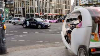
    more info
  • MyWay

    European Smart Mobility Resource Manager

    Kreuzung am Potsdamer Platz mit verschiedenen Fahrzeugen
    © Philipp Plum / Fraunhofer FOKUS

    MyWay project investigated, developed and validated an integrated platform, the “European Smart Mobility Resource Manager”, including cloud-based services and facilities to support community supplied information collection and processing.

    more info
  • TEAM

    Tomorrow's Elastic Adaptive Mobility

    Person sitzt in einem stehenden Auto hinter dem Lankrad und bedient mit der rechten Hand ein Navigationspad auf dem die TEAM App läuft.
    © Fraunhofer FOKUS

    The project TEAM is aimed at developing new collaborative mobility solutions and addresses two important challenges in the present time: Designing an infrastructure, which is capable of meeting the increasing traffic demand and decreasing pollution.

    more info
  • Location-as-a-Service

    Location-as-a-Service for a highly accurate localization

    »Location-as-a-Service« (LaaS) hilft bei der Vernetzung verschiedener Verkehrsteilnehmer.
    © Philipp Plum / Fraunhofer FOKUS

    Assistance systems, such as GLOSA, collision warning, and Digital St. Andrew's Cross, can increase safety and comfort for road users, but also improve efficiency. For these assistance systems to be available to VRUs (“Vulnerable Road Users”) as well as passenger cars, highly accurate positioning is necessary. It is crucial to assign road users to the correct lane on a road, for example, to determine the correct traffic light sequence or to detect a possible collision.

    more info
  • PRE-DRIVE C2X

    Preparation for Driving implementation and Evaluation of C-2-X communication technology

    German Autobahn near Munich, blurred headlight, blurred truck in foreground
    © istock / manwolste

    The European Research project PRE-DRIVE C2X aims to specify a detailed architecture and to realize a pan-European C2X-system, which is a communication system for vehicles exchanging relevant information with other vehicles or with equipped traffic infrastructure.

    more info
  • DIGINET-PS

    The Digitally Connected Protocol Route - Urban Test Field for Automated and Connected Driving in Berlin

    Simulation der DIGINET-PS Teststrecke in Berlin mit VSimRTI
    © Kai Royer / Fraunhofer FOKUS

    In the DIGINET-PS project, connected and automated driving is researched in the urban test field of Berlin. The focus is on combining modern smart city technologies with future vehicles.
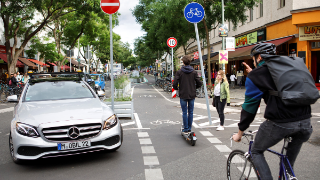
    more info
  • Shuttles&Co

    Digital test field Berlin

    Collage: Blick durch die Frontscheibe eines Linienbusses (ausgegraut), eingefügt darin ein Ausschnitt der Echtzeitverkehrsanalyse durch die im Projekt Shuttles&Co entwickelte App auf einem Smartphone.
    © Fraunhofer FOKUS

    In Reinickendorf, Berlin, automated vehicles and new communication technologies are used to test and further develop safety and comfort in digital urban traffic.

    more info
  • Ein blinder Mann mit Hut, Sonnenbrille und Langstock steht an einer Bushaltestelle.
    © Shutterstock / Halfpoint

    During the “Ride4All” project, a model route for barrier-free public transport will be established over the next two years. Users will travel from the Soest to Paradiese station in automated minibuses, while being accompanied by a inclusive, highly accurate app.

    more info